My country of origin
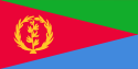 The Flag of Eritrea
 The Coat of Arms
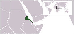
As you all know I am from the state of Eritrea. The name is derived from the latin word for Red Sea, Mare Erythraeum. The country is bordered by the Sudan in the west, Ethiopia in the south, and Djibouti in the southeast. The east and northeast of the country have an extensive coastline with the Red Sea.
Modern Eritrea was consolidated into a colony by the Italian government on January 1, 1890. Contemporary Eritrea gained its Independence from Ethiopia after a thirty year war which began on September 1, 1961 ending on May 29, 1991. The peoples of Eritrea share a long and complex history with neighboring peoples.
Eritrea is officially a parlimentary democracy consisting of six regions and defines itself as a multilingual and multicultural nation. The two dominant religions are Orthdox Christianity and Sunni Islam; there are nine nationalities, each with a different language. There is no official language in Eritrea, rather it has three working languages, Tigrinya, Arabic, and English, and Italian is still sometimes spoken as a commercial language. Eritrea is also a mineral rich country with large deposits of gold, silver and copper.
Eritrea is officially a parlimentary democracy consisting of six regions and defines itself as a multilingual and multicultural nation. The two dominant religions are Orthdox Christianity and Sunni Islam; there are nine nationalities, each with a different language. There is no official language in Eritrea, rather it has three working languages, Tigrinya, Arabic, and English, and Italian is still sometimes spoken as a commercial language. Eritrea is also a mineral rich country with large deposits of gold, silver and copper.
Eritrean history is one of the longest of Africa and even the world. Together with Abyssinian and the southeastern part of the Red Sea coast of Sudan, it is considered the most likely location of the land known to the ancient Egyptians as Punt (or "Ta Netjeru," meaning land of the Gods), whose first mention dates to the 25th century BC.
The modern name is the Italian form of the Greek name ΕΡΥΘΡΑΙΑ (Erythraîa;), which derives from the Greek name for the Red Sea (ρυθρ Θάλασσα).
The modern name is the Italian form of the Greek name ΕΡΥΘΡΑΙΑ (Erythraîa;), which derives from the Greek name for the Red Sea (ρυθρ Θάλασσα).
Eritrea is located in the Horn of Africa and is bordered on the northeast and east by the Red Sea. The country is virtually bisected by one of the world's longest mountain ranges, the Great Rift Valley, with fertile lands to the west and the descent to desert in the East. Off the sandy and arid coastline is situated the Dahlak Archipalego and its fishing grounds. The land to the south, in the highlands, is slightly less dry and cooler. Eritrea at the southern end of the Red Sea is the home of the fork in the rift.
The Arfar Triangle or Danakil Depression of Eritrea is the probable location of a triple junction where three tectonic plates are pulling away from one another: the Arabian Plate, and the two parts of the African Plate (the Nubian and the Somalian) splitting along the East African Rift Zone (USGS). The highest point of the country, Soira, is located in the centre of Eritrea, at 3,018 metres (9,902 ft) above sea level.
The main cities of the country are the capital city of Asmara and the port town of Assab in the southeast, as well as the towns of Massawa to the east, and Keren to the north.
This concludes our first segment in our 163 part series BETTER KNOW A COUNTRY
posted by Josh at 7:35 PM
![]()
![]()

0 Comments:
Post a Comment
<< Home